July 6
10 p.m.: The Flood Watch has expired.
7:55: The Flood Watch has been extended through 10 p.m. tonight.
The messaging from the US National Weather Service Austin-San Antonio Texas remains the same as it has all day. The watch is in place because there is a risk of flooding should excessive rainfall occur tonight. Rainfall amounts of 2 to 4 inches with an isolated 10 inches across the central Texas region are possible tonight.
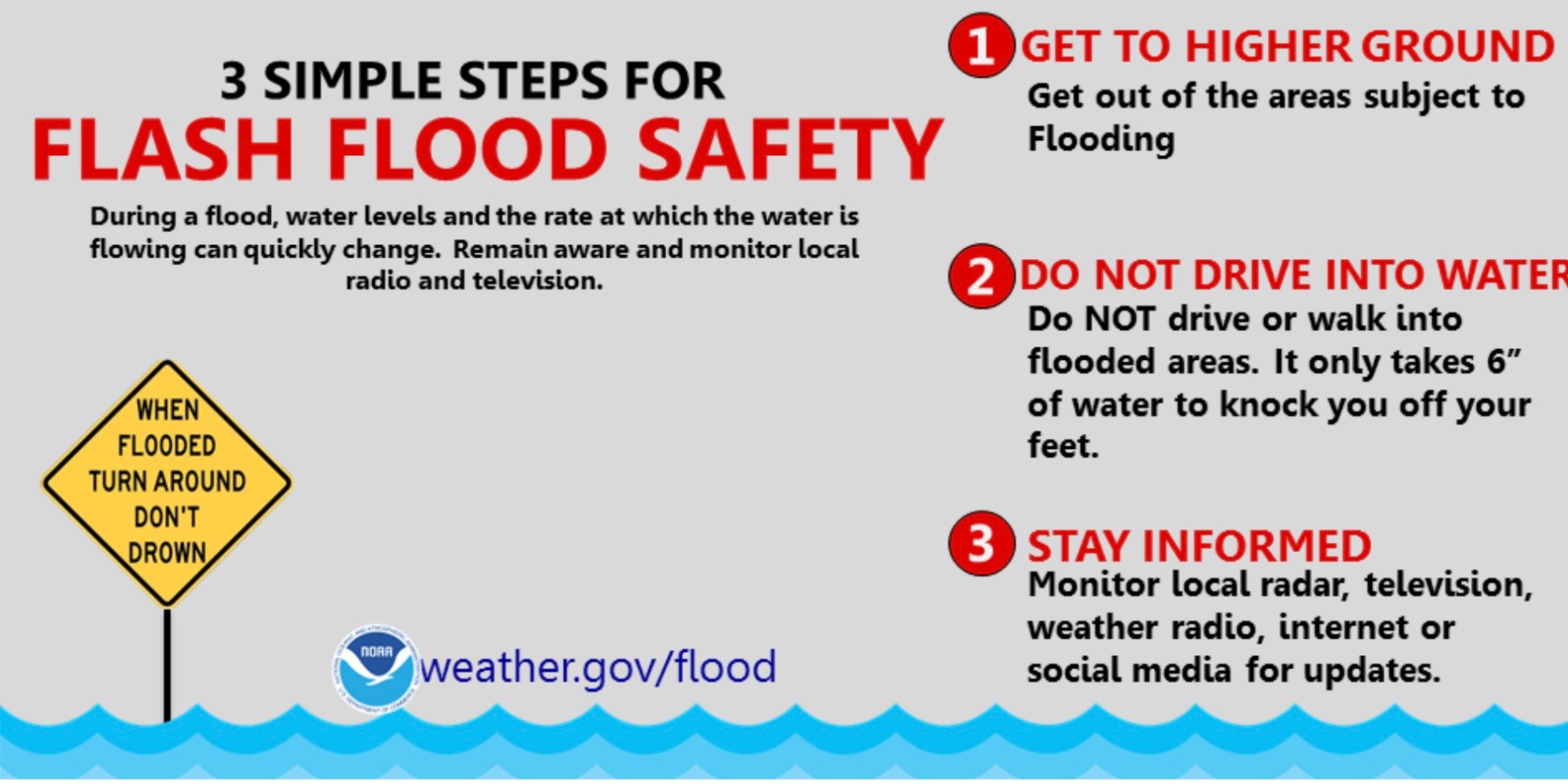
Remember, if you encounter high water while driving, turn around, don't drown!
------------------
The flood watch for Caldwell County has been extended until 7 p.m. There is a 30% chance of thunderstorms after 4 p.m. Flooding caused by excessive rainfall is possible. Rainfall amounts of 2 to 4 inches with isolated 10 inches possible, the US National Weather Service Austin-San Antonio Texas says.
Multiple low water crossings throughout the county remain closed. Please do not drive through barricades. See the full list here: https://www.co.caldwell.tx.us/page/article/1165
July 5
10:30 p.m.: The flood watch has been extended until 1 p.m. Sunday, July 6.
3 p.m.: The flood watch has been extended until 10 p.m. for Caldwell County.
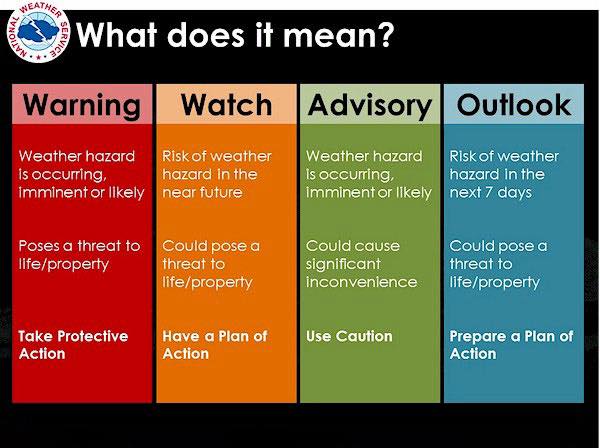
A Flood Watch is issued when conditions are favorable for a specific hazardous weather event to occur ... when conditions are favorable for flooding. It does not mean flooding will occur, but it is possible.
Please exercise caution if you must drive. On average, flooding claims nearly 90 lives each year, according to national statistics. More than half of these deaths occur in motor vehicles when people attempt to drive through flooded roadways.
It is never safe to drive or walk through flood waters. Any time you come to a flooded road, walkway, or path, follow this simple rule: Turn Around Don’t Drown.
July 5
12:05 p.m.: The flash flood warning has been extended until 3 p.m. for southwestern Caldwell County.
9:30 AM:
The National Weather Service has issued a Flash Flood Warning for Caldwell County that is in effect through noon today.
Here is the full report:
At 8:56 a.m., Doppler radar and automated rain gauges indicated thunderstorms producing heavy rain across the warned area. Between 1 and 3 inches of rain have fallen. Additional rainfall amounts of 1 to 3 inches are possible in the warned area. Flash flooding is ongoing or expected to begin shortly.
HAZARD...Life threatening flash flooding. Thunderstorms producing flash flooding.
SOURCE...Radar and automated gauges.
IMPACT...Life threatening flash flooding of creeks and streams, urban areas, highways, streets and underpasses.
Some locations that will experience flash flooding include...San Marcos, Lockhart, Martindale, Uhland, Mustang Ridge, Niederwald, Brownsboro, Dale, McMahan, Lytton Springs, St. John's Colony, Tilmon, Taylorsville, Mendoza, Maxwell, Delhi, Reedville and San Marcos Regional Airport.
PRECAUTIONARY/PREPAREDNESS ACTIONS...
Turn around, don`t drown when encountering flooded roads. Most flood deaths occur in vehicles.
Be aware of your surroundings and do not drive on flooded roads.
Stay away or be swept away. River banks and culverts can become unstable and unsafe.
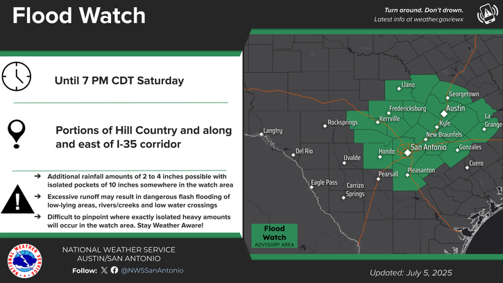
7:30 AM: The National Weather Service has issued a Flood Watch and a Flood Advisory for Caldwell County as well as much of central Texas.
Please stay off the roads as much as possible today and keep an eye on local forecasts. Make sure you are signed up to receive emergency alerts at www.warncentraltexas.org.
At 640 a.m., Doppler radar indicated heavy rain due to thunderstorms. This will cause small stream flooding. Between 1 and 3 inches of rain have fallen. Flooding caused by excessive rainfall is possible, with rainfall amounts of 2 to 4 inches with isolated totals up to 10 inches also possible.
Excessive runoff may result in flooding of rivers, creeks, streams, and other low-lying and flood-prone locations. Creeks and streams may rise out of their banks.
Small stream flooding caused by excessive rainfall is expected.